Updated June 3, 2023
Difference Between QGIS vs ArcGIS
The alternative between Microsoft Office and Google Docs is more likely to distinguish between QGIS vs ArcGIS. The leading GIS apps are both QGIS and ArcGIS. With just a few variations, they are almost identical. Both are two big channels with which anyone can operate. Depending on the resources it provides and its price effects, you can choose between QGIS and ArcGIS. Both methods will help you work as long as you know how to use them to draw your conclusion properly. But between the two applications, there are several essential variations to remember before deciding what GIS project to use.
What is QGIS?
While ArcGIS remains the standard, QGIS is a common alternative to commercial GIS software options. QGIS, like the Austrian state of Vorarlberg and the cantons Glarus and Solothurn in Switzerland, have taken over many private and public bodies. While the ArcGIS standard remains, QGIS is a common alternative to commercial GIS software. Numerous public and private organizations, including Vorarlberg, Austria, and the Swiss Cantons of Glarus and Solothurn, have taken over the QGIS.
What is ArcGIS?
ArcGIS is a GIS program that enables geographical information to be managed and analyzed by visualizing geographical statistics through layer-building maps such as climate data or trade flows. It was used to establish and demonstrate groundbreaking research by several universities and institutions in the humanities and the sciences. It is also used by numerous governments and commercial/private organizations worldwide.
Head-to-Head Comparison Between QGIS vs ArcGIS (Infographics)
Below are the top differences between QGIS vs ArcGIS:
Key Differences between QGIS vs ArcGIS
Some of the key differences between QGIS vs ArcGIS are explained in detail below:
- ArcGIS projects the data “on the move” as other data sets are inserted in other coordinates. This ensures that the layer matches the first layer and coordinate scheme of the data frame. QGIS supports 2,700 established reference systems of coordinates (CRS). It allows the global and projected CRS to be specified for layers without a predetermined CRS. On the fly, you can also describe custom CRS and support vector and raster layer projection.
- “Sounds like a bad film, licensed to geoprocess.” ArcGIS is the enemy that forces you to log in. The open-source hero is QGIS.
- The geoprocessing system for ArcGIS is powerful. Quite strong. Very strong. Quite wide-ranging. Your license standard, however, defines which ArcGIS instruments you can use. License levels in QGIS are not available. QGIS Open Source Software does not restrict the use of resources.
- You need to know the tool well in advance in QGIS. It’s not a bad thing. But the silver dish like the ArcGIS 10 doesn’t come with you. ArcGIS exploratory regression tools are suitable for users to link statistics with information since the outputs enable them. For analysts, this saves time.
- ArcGIS is charged on startup with excellent symbology. We like discipline symbology. For point, line, and polygon types, it’s perfect. The current ArcMap symbology is beautiful, handy, and abundant. If QGIS were fitted with symbology, such as trains and hatched polygons, it would simplify life by not missing the beat for current choices. Remember that you can download and load them to your palette of symbologies and load them.
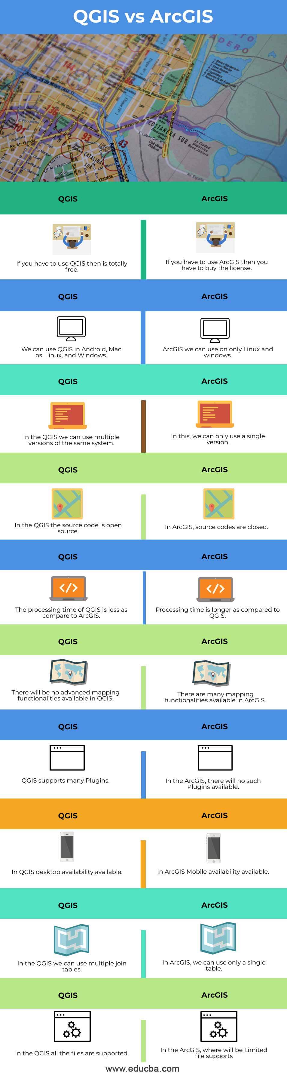
Comparison Table Between QGIS vs ArcGIS
A comparison table is a perfect medium for understanding the main facts of different software. So here we have several facts in our table, and these are as follows:
|
Sr. No |
QGIS |
ArcGIS |
| 1 | If you have to use QGIS, then it is free. | If you have to use ArcGIS, you must buy the license. |
| 2 | We can use QGIS in Android, Mac os, Linux, and Windows. | ArcGIS we can use on only Linux and Windows. |
| 3 | In the QGIS, we can use multiple versions of the same system. | In this, we can only use a single version. |
| 4 | In the QGIS, the source code is open source. | In ArcGIS, source codes are closed. |
| 5 | The processing time of QGIS is less as compared to ArcGIS. | Processing time is longer as compared to QGIS. |
| 6 | There will be no advanced mapping functionalities available in QGIS. | There are many mapping functionalities available in ArcGIS. |
| 7 | QGIS supports many Plugins. | In ArcGIS, there will be no such Plugins available. |
| 8 | In QGIS, desktop availability is available. | In ArcGIS Mobile, availability is available. |
| 9 | In the QGIS, we can use multiple join tables. | In ArcGIS, we can use only a single table. |
| 10 | In the QGIS, all the files are supported. | In ArcGIS, you have limited file support. |
Conclusion
In this article, we have seen key differences between QGIS and ArcGIS. You can choose any of them based on your requirements.
Recommended Articles
This is a guide to QGIS vs ArcGIS. Here we discuss the QGIS vs ArcGIS key differences with infographics and a comparison table. You may also have a look at the following articles to learn more –